|
MOUNT WILLIAMSON
JULY 1989
(2nd attempt)
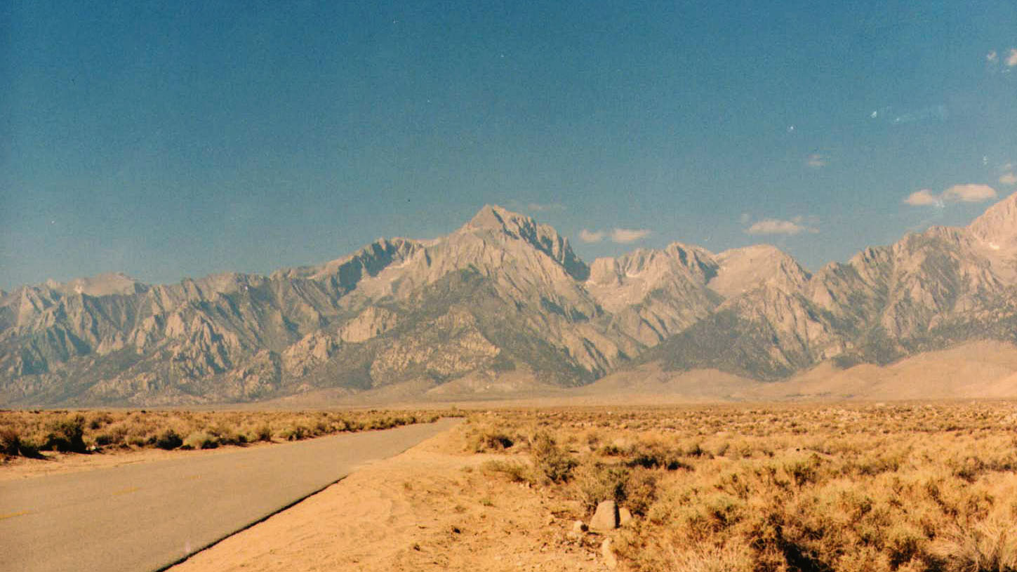
Mount Williamson is the second highest peak in
California at 14,375 feet above sea level. In the list of North
American peaks it's ranked right below 14,410 foot Mount Rainier in
the state of Washington. Williamson is in the area of the head waters
of the Kern River which contains many of the highest peaks in the state including the highest Mt. Whitney. Williamson can only
be climbed certain times of the year because it is part of the
California Bighorn Sheep Zoological area and entry is restricted during the period from mid July to mid December. To reach
the mountain the easiest way is through Shepherd Pass. Shepherd Pass is not actually that easy and according to some of the
trail books I've read it is the hardest pass in the Sierras. At the
ranger station where they rate the difficulties of the various local routes it is listed as very strenuous. The trail head
to the pass and therefore the mountain is Shepherd Pass Trail Head
which is just outside of Independence in the Owens Valley.
Mike and I had tried climbing Williamson around Memorial
Day weekend in 1988 but had abandoned our attempt at 12,400 feet when a late season blizzard came through the Sierras. This
second attempt was to also be a failure, partly because we initially
were unable to find the correct route to the summit, but mostly
because I was in very poor physical shape and didn't feel like making a second attempt once the route was known. This 1989attempt was turned back at 13,600 feet. Well there's always
next year and as they say "third times a charm".
Being the second attempt at Williamson, from the same trailhead, we didn't need to stop in Independence to get
directions. The first time one of the locals at the corner bar
hadn't appreciated me too much and Mike had to get the directions.
Onion Valley Road going west out of downtown Independence (must be downtown they have a caution light) is paved at least
until it gets to the left turn onto the dirt Foothill Road. Foothill
runs to a corral area then brokenly works its way up another mile or so to the Shepherd Pass trail head at about sixty two
hundred feet in elevation.
The trail head parking was pretty full and we were lucky
to find a parking spot. The rangers at Lone Pine had told us that the trail was being worked on and that the work included
some delays caused by dynamiting. We assumed most the cars belonged to
trail workers since we were also told by the rangers that they had only recently issued permits for two other people into
the Shepherd Pass area. But then again you can never go by who
bothered to get permits. Having eaten breakfast at Denny's in
Ridgecrest, and driven to the trail head afterwards, we managed to get on the trail a little after nine that Wednesday morning.
Not far from the trail head we found a hand written
sign attached to one of the permanent signs telling us about a
possible hour delay due to dynamite work ahead at the pass. It didn't really matter at the time since we weren't planning
on making the pass the first day, or a least I wasn't. The trail
continued on towards a steep walled canyon for a while than fell in along Symmes Creek. About the same time the trail
started following the creek there was a cut off going back down the
creek to the corrals.
I knew almost right away that I was going to have a
terrible time trying to keep up with Mike. I hadn't had a beer
or cigarette since the night before, but over twenty years of heavy
smoking and drinking seemed to have finally caught up with me all at once. I had almost no wind in my lungs and no endurance at
all and we were still relatively in the lowlands. The way I was
feeling I didn't think I was going to make it to Anvil Camp that day, which had taken almost eleven hours of hiking the
year before. I guaranteed Mike I would make it a least to Symmes
Saddle without having a heart attack and he pushed on ahead by
himself.
The trail worked its way up Symmes Creek crossing it
four times before finally leaving it to climb up out of the valley. At
every crossing I took a break and doused my ball cap in the coldwater to try and cool my head. The day was warm and although
I was wearing shorts and a short sleeve shirt it didn't take long to work up a sweat. I think I should get a white sun hat
the black SF Giants cap I was wearing seemed to heat my head instead of protecting it from the sun. The creek was often shaded by
the small trees growing along side it and when the trail occasionally
passed through the trees the shade was a welcome relief from the
glaring sun. Before leaving the last trail crossing of the creek I
made sure my water bottles were full. I was carrying three and a half
quarts of water or about seven pounds worth. I didn't expect to see water again until we reached Anvil Camp sometime the
next day. The trail had been fairly straight and easy going to the
point where it left the creek, gaining about eight hundred feet over the first couple of miles. After that it became mostly
steep switch backs climbing up two thousand feet in elevation to the
nine thousand foot pass which was Symmes Saddle.
The first major set of switch backs after leaving the
creek were pretty much in the open. I wished I had bothered to put on
some sun screen, especially on my legs, which weren't used to seeing much sun. As the trail began to rise along an
eastern rocky ridge the rocks began to take on some pretty colors.
Some of the color was due to minerals in the rock such as a greenish
blue from deposits of copper. Other colorations was due to
organic sources mostly lichen. The lichen stained the rocks with
splotches of red, yellow, orange, green, and blue and looked as if they had been splattered there by some strange op artists brush.
Another thing I had noticed from the start, splattered
along the trail, was road apples. I assumed the people working on the
trail didn't have to hike all their supplies in on their backs and that the horses were being used to support them. After
the first set of switch backs the trail remained in the open for awhile gradually gaining elevation until it reached the
second major set of switch backs. These switch backs were among the
trees that reached up the final twelve hundred feet to the pass. The trees provided some shelter from the sun but also provided
an assortment of bugs. I easily recognized mosquitoes and their
threat but along with these were also small flies with a greenish banded abdomen which also bit. Instead of sun screen I began
to wish I had bothered to put on some insect repellant. They were
especially bad on my legs each time I stopped to take a break which was often. If God hadn't wanted me to sit down so often
he wouldn't have put so many good sitting rocks along the trail.
The weather had changed from bright sunshine to the
often common high Sierra afternoon thunder heads. The clouds
intermittently released light showers but luckily with no real
intensity. The light rain was just enough to be a relief from the hot sun and only once did I even consider purposely
seeking shelter under the trees. The trail was very irregular and I
found myself often maneuvering among exposed tree roots and small
rounded boulders. Occasionally I would glance at the surrounding
terrain and see parts of another trail which hadn't been there the year before. It turned out they were putting in a new
trail whose purpose is to get rid of the sharp cornered steep switchbacks which lead the final distance to the pass. I'm still
not sure if the changes are to make it easier on the hikers or the
horses, more than likely the horses. I imagine they have some
problems making the sharp turns and finding their way over the
erosion sculptured surface of the old trail.
Since I was carrying an altimeter I had a good idea when
I was almost to the pass both by the altitude reading and the
apparent leveling off of the trail. Near the top I was greeted by Mike who was wearing a light plastic poncho because of
the sprinkles. What had taken him four hours to complete took me
closer to six and a half hours. The pass itself is a nine
thousand foot saddle which happened to be occupied at that time by a horse support station. There weren't any horses there
when we arrived but the aroma was unmistakable. We decided to continue
down the trail to the second saddle which is pretty much at the same elevation and is easily reached by a transverse route
along the side of a connecting ridge.
When we stopped for the day we were left with almost
five hours of remaining daylight which was somewhat unusual for us but
definitely enjoyable. When Mike and I go climbing I usually end up stumbling into a near dark camp after ten or twelve hours
of hiking. I might have been able to make it to Anvil Camp by dark but the way I was feeling I didn't feel like pushing
myself especially with four days still to go. We were greeted at our
selected camp site by a young buck but he didn't seem inclined to stick around for dinner. The camp area was mostly dotted
with short scrubby trees or bushes and sandy open spaces. Looking
around there didn't seem to be any trees worth trying to use for an attempt to bear proof our food supply. We decided to
hope bears didn't peruse the area or if they did the deer would scare
them off.
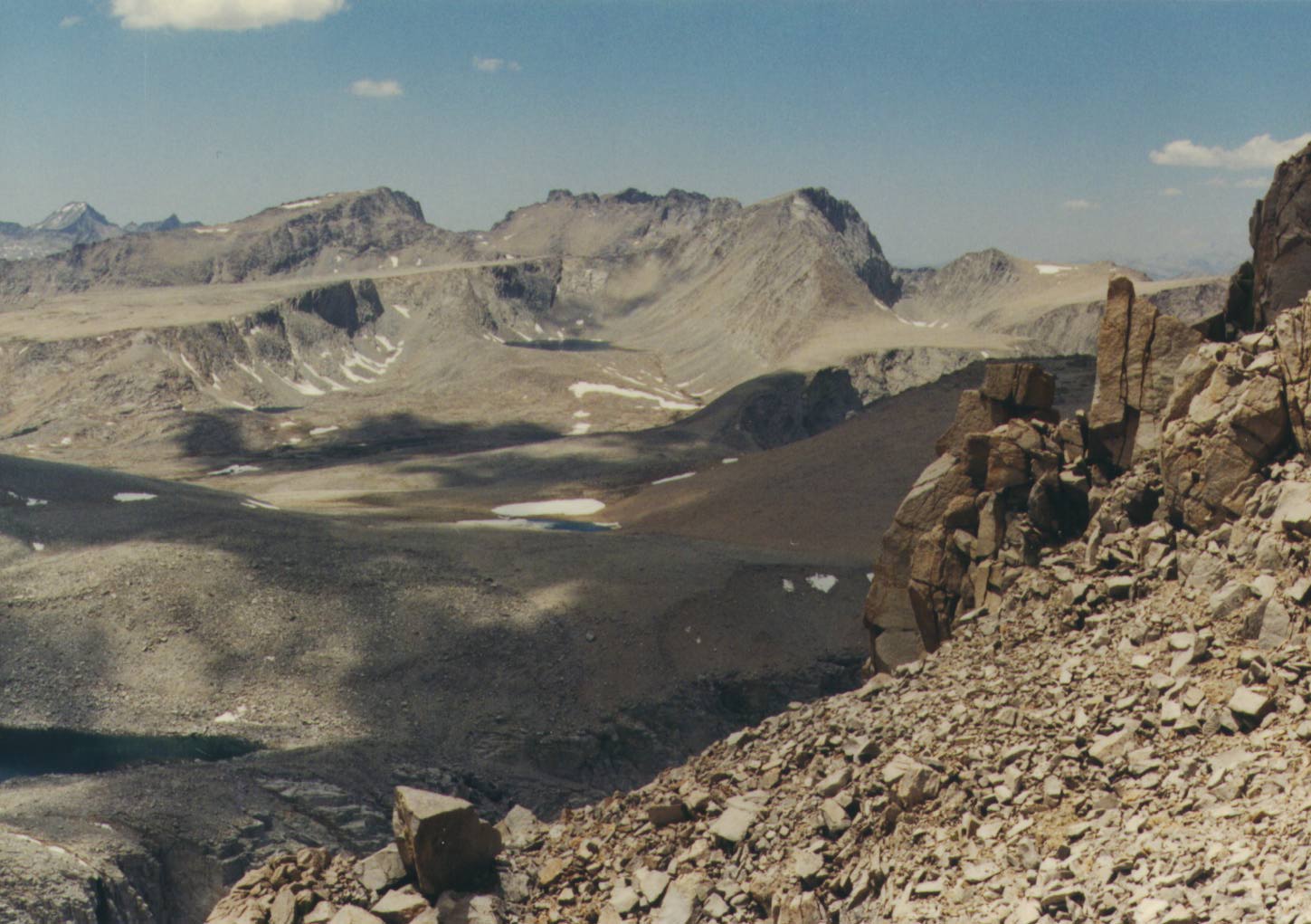
The horn on the saddle was several hundred feet above
our camp and from it the vertical view down several thousand feet to
Shepherd Creek was impressive. Studying the terrain a passable route through the lower part of the creek wasn't easily
evident and probably didn't exist. There's probably a good reason why
the trail starts in Symmes Creek and climbs through the saddle before
dropping down to Shepherd Creek. Across the steep walled canyon and behind an eleven thousand foot ridge stood the massive
square blocked top of Mt. Williamson. From every side Williamson
displays jagged spires and false summits which make picking the
correct route for the climb important. Our attempt at the summit was still two days away and would come from the southwest
side not the northern side that was visible from the saddle.
Back at camp we erected the new expedition quality
four season tent I was carrying for the first time. The weather was
clearing and there really wasn't much chance of rain but Mike wanted to be sure he knew how to put it up. Mike slept out
under the stars that night but since I had never slept in it before,
and we had gone through all the trouble of setting it up, I slept in the tent. I reached camp with two and a half quarts of
water and decided to splurge and use over a quart and a half for
dinner. One quart went to make some nasty tasting milk which
provided instant pudding with dinner and instant breakfast the next morning. The rest went to a macaroni and cheese dinner
and Tang.
Just around dark two hikers came through our camp
heading towards the higher country. It seems they hadn't bothered
using the trail instead they had came straight up the shoulder of Mt
.Keith which separates the two creeks. They told us it looked easy on the map but was rather hairy in spots with vertical
cliffs .When you have a topo map with eighty foot contour
intervals cliffs shorter than eighty feet don't show on the map but
are still there. Even with their unorthodox approach they still made as good a time as I had on the trail. It's was really nice to
be reminded of how bad a shape I was in. They were almost out of
water but we didn't have any to spare and they didn't ask. I told hem the next water wasn't until Anvil Camp and they took
off into the night.
About seven thirty the next morning, after an
instant breakfast, we packed up and headed up the trail, which
was actually down the trail. From the saddle the trail loses about
five hundred feet in elevation before climbing back up again. We
crossed one dry steam bed but the second one we came to had water
flowing in it. It had been flowing at the end of May the year before but we hadn't expected it to be still flowing in July.
The two hikers who had come through the night before had made camp
near the stream whose water had been a big relief to them when they stumbled upon it in the dark. Between the first dry
stream and the second wet one the trail had started up again. I had sent
Mike on ahead but I found him waiting at the stream when I
arrived. After leaving the stream we agreed to meet at Anvil Camp and Mike again went on ahead rather than wait for my snail
paced progress.
At one point along the trail between the saddle and
Anvil Camp we came across a long handled pruning saw stuck in the
ground and a half full litter bottle of water in the shade of a rock. Other than that and the horse droppings there hadn't
been any indication the four of us weren't the only ones for miles
around. A little farther up the trail I came to Mahogany Flat which isn't truly flat but is close. I'm not sure what
Mahogany looks like but the area was mostly covered with low Manzanita
and occasional trees. There I met a man and a woman who were coming
down from the high country. When I asked them about the condition of Shepherd Pass they told me they had come down through
Junction Pass but as far as they knew Shepherd Pass was open. At the upper end of Mahogany Flat the trail goes through
a series of about half a dozen long switch backs. One set in
particular seems to take miles to complete. Mike and I had
decided to try and bypass the switch backs by climbing up a rocky stream bed which the trail eventually crossed further up. I
could see Mike up ahead of me seemingly having some problems making
progress in the rough terrain. I abandoned the trail and tried to make my way through the dense Manzanita toward the stream
bed. Mike was yelling something I couldn't understand, but when I
noticed the other two guys had stayed on the trail and were ahead of me in the right direction, I back tracked to the trail
and followed it for a while farther. That turned out to be what Mike
was yelling about.
The only advantage to climbing the stream bed was that
there was water running in the lower portion of it and it provided me a
good excuse to sit down and take a break. It gave me a chance to
replenish the pint of drinking water I carried in easy reach and to douse my head with cold water, the day was sunny and warm
just as the day before had been. The climb ended up being slower and
harder than using the switch backs but it was a change of route from the previous trip and worthwhile for the comparison. Up
the draw I finally picked up the trail again and after crossing a
rock strewn field entered the large shady trees of Anvil Camp. I found Mike in the shade along the creek sometime shortly afternoon, it had taken me almost five hours that day to reach
that spot. I didn't bother asking Mike how long it had taken him, I
was feeling bad enough
. I decided I was going to take a good break of at least
an hour and if it was just up to me I might have considered calling it a day at that point. But then again there was still over
eight hours of day light and I had taken it fairly easy the day before.
I told Mike I would meet him at the lake in Shepherd Pass and he headed up the trail by himself. Mike would rather hike in
one long sprint and the sooner he could take his pack off for the day
the happier he was. Me I would rather take my time stopping
frequently to smell the flowers along the way, between gasps for
breath. The only problem the last couple times out is the long days with the heavy pack are starting to really get to my back.
The trail up and away from the creek starts out
climbing among the roots of the densely packed large trees, but in
fairly short order the trees thin out some and eventually are replaced
by a large pile of boulders. Just at the edge of the trees before the boulders I ran into the first of many marmots I would see
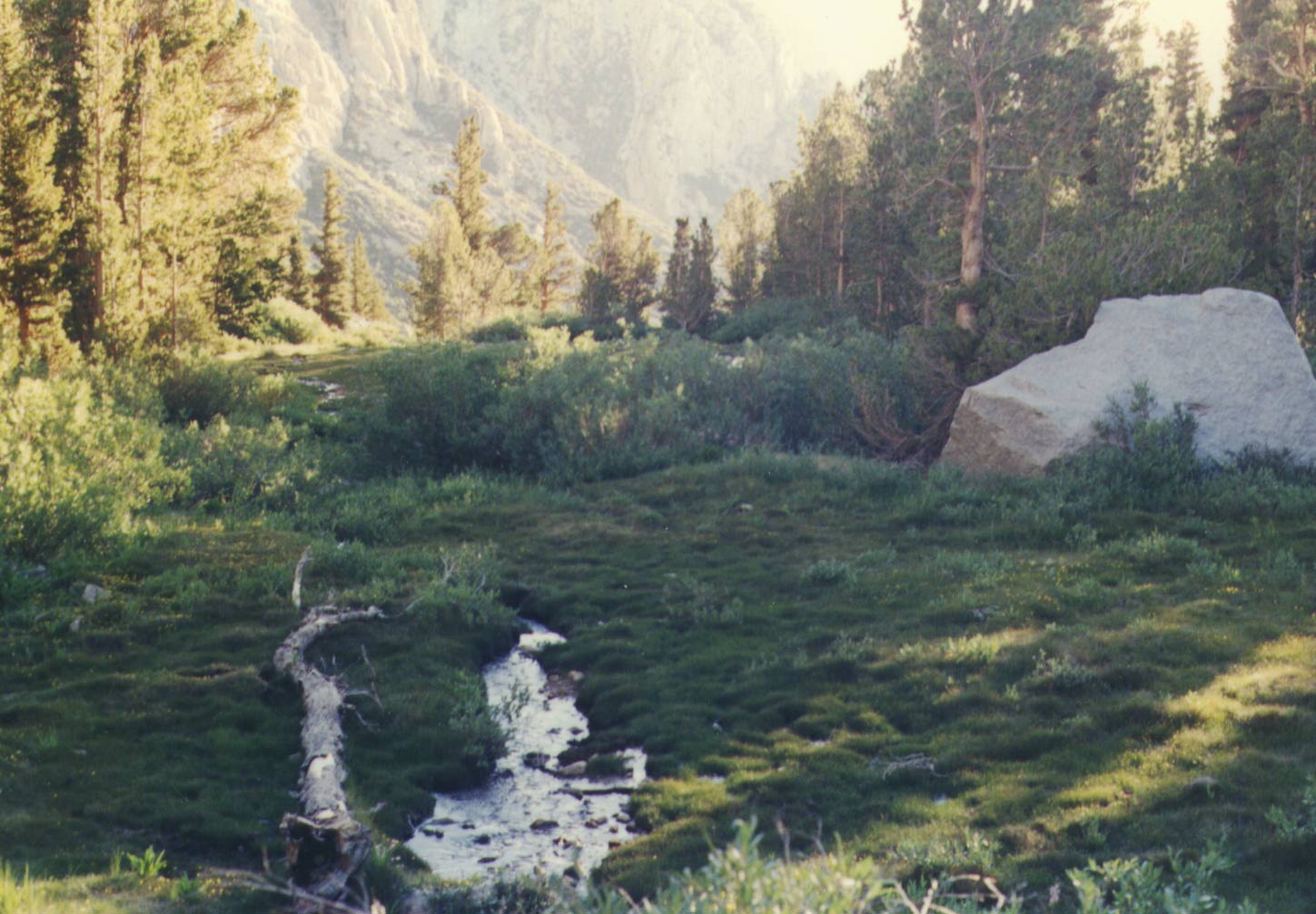
on the trip. After navigating the edge of a huge slide of large
boulders the trail drops down into the Pothole at about ten
thousand eight hundred feet. The Pothole is about five hundred feet above Anvil Camp but still twelve hundred feet
below Shepherd Pass. It is a brushy meadow where the streams coming
down from Shepherd Pass and the higher Junction Pass join
together. Although not shown on the map that I carried there was a sign at the Pothole indicating a trail to Junction Pass.
Junction Pass is almost a thousand feet higher than
twelve thousand foot Shepherd Pass and is between Junction Peak and Mt.
Keith. Mt. Keith has a mostly red appearance and its summit misses the fourteen thousand foot level by a mere twenty
three feet. A major feature looking at the southern side of Keith is a
huge steep slide area which appears to start at almost the top of the peak and extends down several thousand feet. The
slide appears to be composed of sand and fine scree, and from The
Pothole it looks as if it would be difficult to climb. Junction Peak, whose summit is less than a hundred feet lower
than Keith's, stretches its lowering shoulder over to Shepherd Pass.
Climbing up the switch backs out of The Pothole I ran
into three of the people who were working on the trail. They informed
me that there wasn't going to be any more dynamiting for a week and that the only part of the trail which was in real bad
shape was near the top. They also told me something I already knew and
that was my partner was a considerable distance ahead of me. After turning down their offer to grab a pick and help them
I continued trudging up the trail, out of the thinning trees,
across the creek and into a flat slab rock open area. The area had a sign announcing it was or wasn't all right for
open herding, depending on which side of the sign you looked at. The
area also had a game warden who was heading down towards the
pothole but managed to stop long enough to tell me something I really needed to know. My partner was quite a bit ahead of me
and was stopped at the base of the pass.
On the boulder strewn ridge after the flat I managed to
lose the trail for a while. Luckily most the knitted boulders were
well seated but it still isn't any fun jumping from boulder to
boulder with a heavy pack on. The next six hundred feet of
elevation consisted of huge fields of large rocks which over the years have fallen away from the higher ridges. The trail
meanders up and down and around these fields until it reaches the base
of the final four hundred feet of elevation to the pass. The final
steep approach is mostly comprised of sand, scree, and small rocks and there was no trail to speak of. It seemed everyone
had taken a route slightly different than the people before them had.
There were many sections which looked like switch backs but they were all isolated from each other and seemed to comprise a
myriad of routes. Starting from the trail head there had been little
wooden stakes in the ground here and there with writing on them to indicate what kind of work should be done on the trail at
that point. The stakes towards the upper portion seemed just a
disoriented as the partially visible unconnected sections of trail.
Afternoon thunder heads had been building above the
high ridge and the sun I had been cursing all day was finally gone.
Somehow relief from the relentless sun didn't seem to make my
climbing any easier. Now every time I stopped to rest I got a chill from the cooling weather and the sudden inactivity. I
hoped the clouds would continue to hold their burden at least until I
got to the top. There didn't seem to be any place to set my pack down to get anything out of it. At least I had managed to put
on a wind breaker at the last stop I had been able to take the pack off at.
The upper couple hundred feet is vertically divided in
half by a large rock mass. The left side was a snow covered chute
while the trail seemed to continue up the clear right side and cross the snow farther up. The climbing on the scree had
been slow going and since I was carrying an ice axe I decided to step
kick up the snow. The ice axe helps with balance but is
especially useful for self arrest if you slip, it saves you the
trouble of climbing the same section twice. When I finally
reached the point where the trail cut across the snow field Mike came back down the fifty yards or so from the pass to greet
me. He told me he had been marking my progress since I had come into
view from the pass hours ago. We went up to where he had left his pack and after almost twelve hours I enjoyed the great relief
of removing my pack for the day.
The two guys from earlier (their names rhymed I think
they were Jim and Tim) had set up their tent on the sandy corner of a
medium sized grassy area. A ranger had been by and had told Mike not to set up camp on the grass so we picked a small flat
ledge just big enough to fit the tent. The grassy area below us still
had a small amount of snow in it and our camp was less than fifty yards from the lake so we had no problem with water. Mike set
up the tent with only a minimal amount of help from me and I
prepared myself a warm dinner. I was tired, sore, and felt I was
burning up from exposure to too much sun. Whether or not I wanted to try and make the summit the next day depended on how I
felt after a good nights sleep.
The Thursday afternoon and evening cloudiness had born
no precipitation and Friday morning broke crisp and clear. After an instant breakfast we downed our day packs and headed for
the summit. The first mile gained about four hundred feet of
elevation and was mostly comprised of a gently rising sandy plain with occasional slabs of rock sometimes with boulders piled
on them. At the end of this easy part of the climb we stood at the rim of Williamson Bowl looking down a steep four hundred feet
to the lakes below. The sign at the rim marking the border of the
bighorn exclusion area was as far as we had reached the year
before. That Memorial Day weekend a blizzard had came in and after spending a night weathering the worst of the strong
winds we had fled from the following day's heavy snow.
The morning sun was striking the upper ramparts
of Williamson at just the right angles to emphasize the many spires and false peaks that formed a maze around its rocky crown.
From where we stood, and from what we remembered being told the year
before, we thought we could see a route up the last southern chute to use to reach the summit. We followed a sandy trail
from the sign over the edge of the rim and down into the bowl. The
trail quickly disappeared and we were forced to climb over
nestled boulders down to a raised runway which separated the first two of the three larger lakes. The bowls floor
wasn't nearly as level as it had appeared from the rim and we had to put
in some ups and downs to reach the third lake in the bowl. There are four lakes in the bowl but one of them is a lot smaller
than the other three.
When we reached the third lake we followed along its
shore and then cut straight for the base of the selected chute on
Williamson. Although I had thought the twelve thousand foot lake would be sterile and void of fish Mike saw some decent sized
ones jumping in one of the first two lakes. The third lake had some
tents pitched along side it but we didn't ask if they had tried any fishing. We could hear people somewhere up on the
higher ridges and figured like us most of them had come to climb rather
than fish. Where our camp at the pass was good for the season the people in the bowl had to be out before that Sunday when
the bighorn exclusion went into effect.
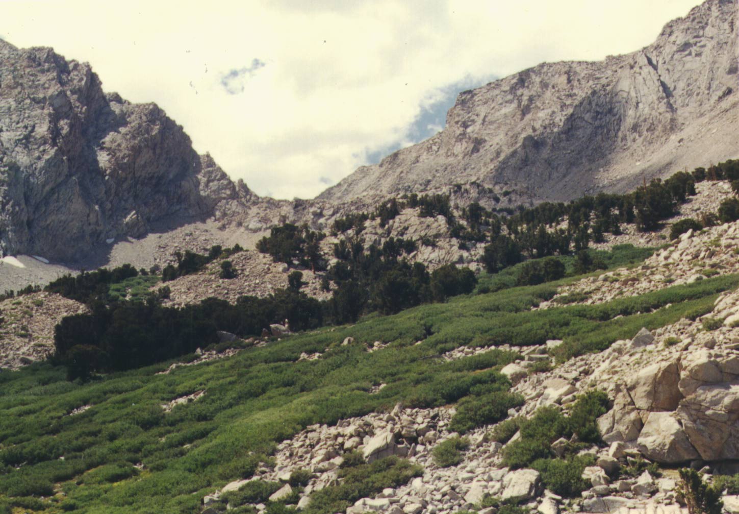
There was a short snow field leading up to the base of
the chute we wanted to start climbing towards the summit, but we
decided to avoid it even though we were carrying ice axes. As we
approached the ramparts of Williamson itself the route we had
selected began to change in appearance. From a distance it had looked extremely steep and composed of sand and fine scree but
as we grew nearer it became evident the rocks in the chute were a lot larger and easier to manage than they had
originally appeared. Up till starting the chute Mike and I had been
pretty much together since leaving camp that morning. As the climb began
to steepen I began to slow down and Mike pushed on ahead. The first couple of pushes he would wait for me to catch up but
each time he had to wait longer than the last. I finally convinced him
that if he wanted to be sure to make the summit he should go for it on his own, I'd be along behind him eventually.
On all the other climbs I've made to over fourteen
thousand feet I've eventually developed headaches due to exertion and
the altitude. This time was no exception, but instead of waiting
until I reached around thirteen and a half thousand feet, I was
already starting to eat aspirin at twelve and a half thousand feet. With as bad a physical shape as I was in I hoped the
only signs of altitude sickness I would develop would be headaches.
If the chute had been full of snow crampons and ice axes would have made it an easier climb than the irregular rocks turned
out to be. Sometimes there would be piles of balanced rocks which
would slip and slide around and at other times there would be some serious solid blocks of rock which needed good holds
to climb. Although there wasn't any snow in the area a small stream
emerged from the rocks evidently being fed from somewhere farther up. Next to the lightly trickling water at about twelve and
a half thousand feet both Mike and I left our useless ice axes. He laid his down but I stood mine up in the center of the
rift hopefully to be a reference on the way down so we didn't lose
them. This is the point where he pushed on by himself, no longer
waiting for me to catch up.
It had taken hours since climbing down from the
northwestern rim but I had finally managed to get above the level we
had started down into the bowl from. The northwestern rim is the
second lowest part of the bowl's steep sides. The lowest part is
actually a missing part of the bowl where the lakes drain out, at about twelve thousand feet, into Williamson Creek which
itself feeds into Shepherd Creek below Symmes Saddle. As I began to
climb away from our ice axes half frozen Lake Helen of Troy began to come into view. The lake sits at a little over twelve and
a half thousand feet but the reason it was still half frozen wasn't its elevation. The lake sits in a narrow box canyon and
is surrounded on three sides by very steep sheltering seven hundred
foot high walls. The only open side, which was facing me, has a
northern exposure. The lake probably got its name because the closed end of the canyon continues up to Trojan Peak which
misses being the third peak on the rim to reach fourteen thousand feet
by a mere fifty feet.
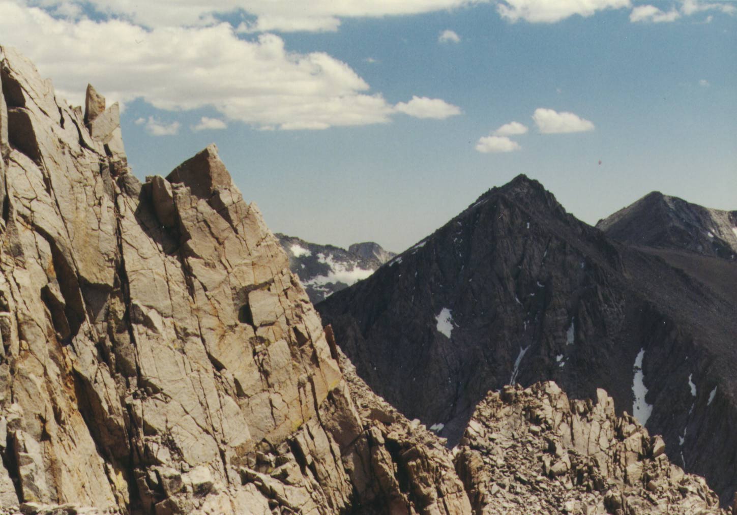
As I began to get above the thirteen thousand foot level
I could start to see over the edge of the southern rim between
Trojan Peak and Mt. Tyndall. The Great Western Divide and the Kaweah Ridge across the Kern Canyon began to show on the ten
mile distant horizon. More to the foreground the two mile distant Mt.
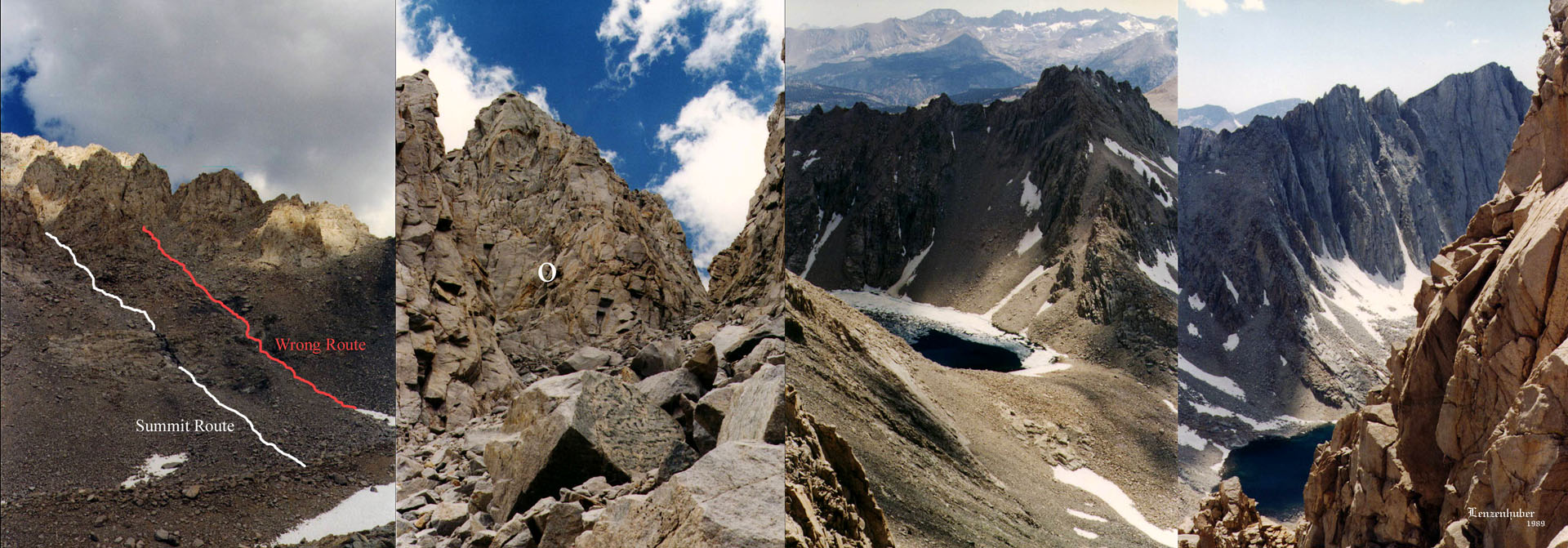
Barnard began to show above the rim slightly askew of Trojan Peak. The route which had looked so easy to follow from
lower down began to get a little jumbled. Just as sometimes you can't
see the forest for the trees it was hard to see the route for the rocks. Originally it had appeared the only major decision was
to keep to the left of a major rock outcrop and not take the right
hand chute. Once I was got to a certain level the major rock
outcropping looked pretty much the same as several others in the area. What had looked like two routes was actually comprised
of several possible routes each turning into its own cleft or
canyon.
About that time I saw Mike who was up on the side of a
vertical rock wall. I really couldn't see what he was trying to gain and then noticed he was heading down. He had managed to
get himself into a rather ticklish situation and it took him sometime to inch his way back down. He told me he was working on
his third dead end and then headed around a corner into another
canyon. It turned out the what we had though was the main route ended in a sky filled cleft. Mike latter told me he had
checked it out and after climbing into the cleft there was a sheer
drop off the other side. There was also a view of a probable summit
approach starting from about the same height as the cleft but that was isolated from the cleft by a sheer rock wall which
also dropped off the side of the mountain. I had nothing better to do
so I followed him into the canyon.
The canyon ended in another dead end, at least for
our purposes without a rope and some friends (pitons etc.). The route to the top supposedly had a spot or two of class III
climbing which could be made without any equipment. Where we had ended
up was definitely class V territory. We sat on a butte which jutted out almost half way up one of the hundred foot sheer walls
and took a break. My altimeter said thirteen thousand six hundred
feet. We were less then eight hundred feet in elevation below the summit but we had no idea where it was or how to get there.
As they say " You can't get there from here." The southern and
western view was fairly decent but definitely no substitute for what the omni directional view must be like from the summit.
To the south behind Mt. Barnard Mt. Russell had come into view and
behind that Mt. Whitney's northern square face was visible. It had been seven hours since leaving camp that morning but we
still had over five hours of daylight left and we were carrying headlamps in case of darkness. Unfortunately we didn't have a clue
as to which way to go so we headed down.
Going down was faster then coming up but the footing was
a little tricky at times. The rocks and small boulders weren't
snugly locked together as they had been in most the other
interlocking piles we had dealt with on the trip. They were
sitting on sand and often we found ourselves skiing downhill a ways on the resultant slides. I was doing so lousy in the
thin air I couldn't even keep up with Mike going down hill but he
slowed down now and then for me to catch up. We located and
retrieved our ice axes without any difficulty and made our way back down to the third lake. After skirting around the edge
of the lake we ran into a man sitting against a rock who told us the
route we were supposed to have used.
Seems there was another cleft not much more than a
hundred yards to the left of the one we took. Where there had been
a little water flowing in the lower part of the route we took the
other rift had a considerable amount more water flowing and it. This left a noticeable shinny black streak on the rocks at
its lower end. Although the routes started side by side ours had
headed up at about one o'clock where as the correct route headed up at an angle closer to ten o'clock. Mike said that he
had noticed that cleft in the mountains face when we had stopped to
retrieve our ice axes. It was too late in the day to start
another attempt so we just continued heading back to camp. As soon as we started heading up out of the bowl I slowed down
and Mike went on ahead back to camp by himself. I finally wandered
into camp about seven thirty in the evening, another long day on the trail but at least it had been without a full pack.
The next day was the last day we could go into the bowl
but I decided I didn't want to bother making another attempt. We had
been planning on climbing Williamson on Friday and then climbing
Tyndall on Saturday morning. We then planned on heading down to Anvil Camp on Saturday afternoon which would give us a little
bit of a head start on the way out Sunday. I didn't really feel I was
acclimating very well and I felt another attempt would been longer and harder, rather than easier, then the previous one.
I was feeling so lazy I didn't even want to try Tyndall but instead
opted for just wandering around and taking pictures of wildflowers. We decided on heading down the gently descending
trail towards the Kern River, I only wanted to go a few miles as to not
lose too much altitude which would only have to be regained going back the other way. I stopped at the start of the trees
still above the eleven thousand foot level but Mike continued on down
towards the river and the denser forest.
I took a short break in the shade and then started
wandering back up to camp, macro lens at the ready. What was a
treeless and brushless environment definitely wasn't void of plant
life although none of it stood over a few inches high. I snapped
pictures of over half a dozen different types of colorful
mountain flowers as well a couple of pictures of the plentiful
marmots. One area, which showed as a swamp on the map, was
actually a luxuriously thick grassy meadow that was braided with
branches of a small stream which had cut its way into the deep soil. In one of the pools in the stream I spied a small
trout about six inches in length.
Once back at the camp I packed my pack and headed down
to Anvil camp. About the only part that was a little tricky was the
upper part of just off the pass. Instead of going down the snow I had come up on I decided to see where the trail went on the
other side of the dividing rock mass. It was the same as the lower
portion of the scree I had been on coming up, it really didn't go
anywhere, or actually went everywhere at once. Climbing down the lose dirt and rock was somewhat easier using an ice axe as
an additional balancing point. Even when there isn't any snow or ice
around I sometimes find an ice axe as something handy and besides it digs nice latrines. Getting from the pass back down
the seventeen hundred feet to Anvil Camp took me a leisurely two
hours compared to the straining five hours it taken me going the other way on the way in. Of course when Mike showed up at
Anvil camp latter in the day it had only taken him one hour to get
there from the pass.
We didn't bother putting up a tent and bedded down just
off the trail where it crossed the creek. Anvil camp itself is only
about a hundred yards wide sitting between two high ridges which over the years have surrounded the oasis with piles of
boulders .It stretches up and down the creek for a while but the
heaviest forestation is only for a few hundred yards. The creek is
the life blood of the oasis as well as to the thirsty hiker. If the
creek is the life blood of Anvil Camp the meadow is the soul. The creek splits off and bubbles into the meadow which is only
about fifty feet wide and a couple of hundred feet long. The meadow was
filled with deep soil supporting rich green grass and delicate wild flowers. Nobody despoils the meadow by setting up camp in
it but when we were there horses had managed to do some minor
damage to it.
Sunday morning we got our earliest start, we broke camp
and started out for the trail head at around seven. I carried two
pints of water which I figured would be more than enough to get me back over the saddle and down to Symmes Creek. Besides I
now knew there was a stream still running just before we had to do
the five hundred feet back up to the saddle. We didn't mess with the stream bed short cut we had tried on the way up and
went ahead and did the long switch backs down to Mahogany Flat. At the
stream I replenished my ready pint of water and soaked my cap for some heat relief. The switch backs up to the first saddle took
a lot out of me and when I reached the top I wasn't in any mood to
hurry up the long gentle incline up to the second saddle. Mike went on ahead and waited for me near the horse station. I
let three people pass me and just before I reached Mike I was passed by a guy riding a horse and leading another.
The trail from the pass back to the trail head was all downhill and I finally managed to get in a good groove
rarely stopping. We tried several sections of the new trail which were
in better shape than the old trail. Then again they hadn't had a chance to see a winter yet or the spring run off. The trip
from Anvil Camp to the trail head took about four and a half hours and
we were back to Mikes truck by eleven thirty that Sunday morning .The three people who had come out the same time we did
had another five people or so still on the trail about to come out,
but they didn't have a car at the trail head. Some of them had hiked in from Whitney Portal then over the Whitney Pass and
into and out of Kern Canyon to get to Shepherd pass. One of them had
his car in the area but had left it down by the corral, miles back down the road. We gave him a ride to his car on our way out.
|